

One day in 1524, the Poole waterfront rang with the sound of sawing and hammering as carpenters constructed a wooden platform on the quay to carry guns. This was not just a grim warlike structure because we know from the town accounts that it was decorated with wooden lions and griffins (from the royal arms) painted by John Nightingale of Christchurch at a cost of 13s 4d (66p). It is a rare and tantalising glimpse of the quay in the early Tudor period. What the quay really looked like at the time is hard to guess. It may not yet have been paved because excavations in the 1970s revealed medieval layers covered by a sandy surface containing 16th century pottery, suggesting that the area was not covered until some time in this century or later.

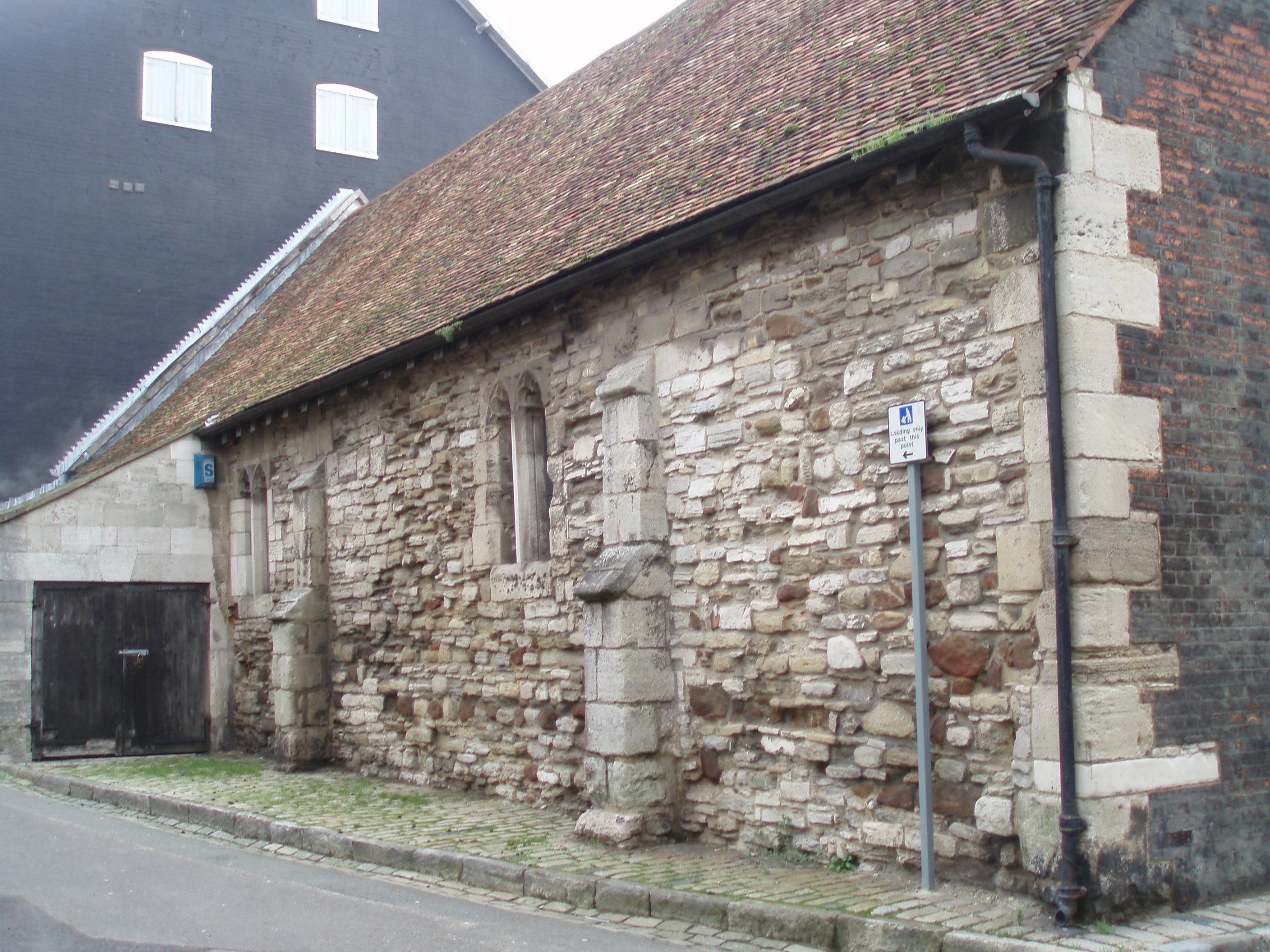
The Town Cellars as it may have looked
The earliest description of the quay comes from a document entitled ‘The Bounds of the Key’, dated 1558. This states that the length of the quay ‘from James Mesurer’s gatte to the key hed which is from the est to the west’ is 80 yards (73 m). ‘From the north side of the key hed to the sowthe side of the same to the low watter marke’ is 16 yards (14.6 m). The description also refers to a howse commonlye cawled the Kynges Halle or Wolle Howse on the northe pte of the key’. The mention of low water mark suggests that the sea did not then come up to the quay at all states of the tide. Perhaps there were jetties from the shore to deeper water or maybe ships moored offshore and were unloaded by carts at low tide. The house of James Mesurer was at the east end of the quay, probably somewhere near the present Museum entrance and a close neighbour to Scaplen’s Court. A small inlet in the shoreline at this point was known as Mesurer’s gap. To the west, the quay ended at the quay head, just beyond Thames Street.
A list of town property of 1563 defined the status of the quay as ‘porchacyd, edefyd and buylded by the towene as well for the ease and commodyte of the straunger as also the Inhabytantes of the same towene’. One ‘commodity’ in use on the quay in Tudor times was a conking-stool or ducking-stool for scolds or gossips. Former property of the brotherhood of St. George purchased by the town included ‘a lyttel prysson by the Keye callyd Salsburye’ and ‘a howse of office upon the Kaye’. The successor to this Salisbury lock-up can still be seen behind the Town Cellars and the house of office or privy remained on the quay into the 18th century.
The rear of the Town Cellars and present Salisbury (far left)
During the next few decades, the proceedings of the Admiralty Court mention the quay quite often in connection with various misdemeanours. For instance ships’ masters are presented to the court for staying too long at the quay, fastening mooring ropes to the quay piles and heaving ballast between ‘the key hed and the stairs’. (The ‘stairs’ or steps seem to have been located about the middle of the quay.) The ‘house of office’ was often reported as being in a poor state. In 1599, it was in decay and ‘lyeth noysomlye not clene kept to the greate nuisance of the Quene’s leage commynge neare unto yt’. The whole area was also frequently encumbered with sunken ships and items left lying about such as planks of wood, ballast and old cannons.
 The earliest map of the quay, dating from around 1597, is on the corner of a map of Brownsea and is orientated with the south at the top. At first sight, the map looks rather crudely drawn but there is actually quite a lot of detail. It shows a single line of quay buildings without the forward projecting area where the Custom House now stands. One of the buildings at the eastern end of the row is presumably James Mesurer’s house. Beyond this is the shore of what is probably Mesurer’s gap and to the west is the quay head. The Town Cellars building is drawn with a chimney or tower on the roof, perhaps a look-out post to observe ships entering the harbour. That the building did have a tower is known from town accounts in the mid 17th century when workmen were paid to demolish it. One mystery is that Thames Street is not shown as blocked by the Town Cellars, as it is probably was at this time, but appears to lead straight through to the quay. Perhaps this can be interpreted as a cart entrance which passed through the building. The Thames Street buildings shown on the map are identifiable with those in old photographs, a point in support of the map’s accuracy.

Old Thames Street houses
In 1600, the quay itself was reported to be decayed with loose posts and ‘walls like to founder’. The following year the authorities were warned again that ‘the posts do bowe and some are wanting’. Repairs were at last started in 1604 and some items in the town accounts show how bad the situation was: ‘to 10 men for careng of the ballast from the Keay hed when it foundered’ / ‘for taking up stones to mend the Key’ / ‘for men to help fill the holl of the key’. However this seems to have been just a temporary measure because in 1611 it was reported despondently at the Admiralty Court that the ‘Great water key of Poole’ was ‘much ruined decaied and fallen downe for want of sufficient repaiering and amending thereof att whose chardge the same ought to be made and donne wee know not’. More repairs were undertaken but the basic problem of congestion remained.
From 1618 to 1620, the Corporation embarked on a long overdue project to extend the quay. Subscriptions were raised and it was finally agreed that ‘the new quay to be built att Mesurer’s gap shall proceed and go forward’. The quay was to be ‘set forthe 8 or 9 foot without Mr Dackham’s further wall and without his wall to make a slype to land horses and lade horses’. George Dackham or Dackombe, mayor in 1619-20, seems to have lived in or near James Mesurer’s former house. The new quay was to be built across Mesurer’s gap at the east end of the great quay and to project forward 2 to 3 metres, giving ships some much needed extra mooring room.
As the accounts reveal, ballast and gravel had to be dug out and a ‘meckson’ or waste dump cleared away (with extra beer, bread and cheese for the workmen), before the ground could be levelled. Boats brought in 90 tons of stones and 8 tons of chalk. Bushels of sand, lime, clay and timber for 65 feet (59.4 m) of piles were purchased. Iron work included 13 shoes for the piles weighing 35lb (15.8kg). There is also mention of ‘takeing downe of the howse at Mr Major’ (or mayor?), so maybe part of George Dackombe’s property had to be demolished. The slip which was 30 yards (27.4 m) long was paved by Matthew Muston and his boys at a cost of 8s 6d (421/2p).

The site of the fish shambles. James Mesurer’s house was also in this area, probably looking out on ‘Mesurer’s gap’.
This major construction was the first of what were to be many extensions of the quay over the centuries. The new area created an opportunity for development and one of the first buildings to be put up there was a fish shambles or market, funded as part of the new quay project. The building stood next to High Street near the present side entrance to the Stable. It seems to have been a small wooden building with caulked walls and a tiled roof and it cost the Corporation £4 11s 6d (£4.571/2p). A line of other buildings followed, constructed in front of part of the great quay (and blocking the view of the harbour from the Town Cellars). By the 1630s when the first detailed map of the town was produced, the area was fairly built up. The quay section of this map (here shown with the south at the top to compare with the 1590s map) shows the new quay projecting forward and new High Street buildings where Mesurer’s gap used to be. Unlike the earlier map, there appears to be no way though from Thames Street to the quay. The steps are shown as a square block in the middle of the quay and there has also clearly been much reclamation of land behind the houses on Thames Street.

The quay in the 1630s
Around 1680, the bounds of the quay were defined again. ‘The Key is 192 feet long, beginning at the dead wall commonly used for heating pitch adjoining to Henry Harbin’s house and land, and WSW along the said Key to the head thereof, with a pair of stone stairs about the middle, being in depth at the said head 42 feet, and in depth at the ENE about 54 feet’. The great quay had therefore lost about 14.5 m of length because of being overlapped by the new quay but was now wider at the eastern end. According to the historian H.P. Smith, the phrase ‘a pair’ of stairs was an old Poolism for a flight and did not refer to just two steps!
Henry Harbin had probably inherited former Dackombe property at the east end of the quay through his wife Mary who was a daughter of George and Edith Dackombe. A later deed gives details of some of his property including premises formerly called the old Custom House containing three messuages and a garden and situated near the quay with the High Street to the east, the King’s Hall (Town Cellars) to the south and the sea to the west. This suggests that the original Custom House was located behind the Town Cellars in or near Salisbury Street before moving to its present location. The deed also mentions property built at the ‘upper end of the Great Key’ on a parcel of ground taken from the sea by Dennis Smith and his father (probably an example of Thames Street reclamation). Poole landowners and merchants had worked to expand the waterfront but by the end of the 17th century the growth of trade meant that it was again becoming inadequate. The scene was set for further expansion . . . .
Jenny

Hi Jenny, interesting reading about my ancestor Henry Harbin who was the Mayor of Wareham. I would love to have more information about him. I understand that his initials are still on the silver mace in the Mayor’s office.
Thanks Grace
Glad you enjoyed the post. I know some basic details on Henry Harbin – although I may be telling you some things you know already. I think he was a mercer ie. a dealer in fabrics and textiles. Besides his Wareham connections he was also Mayor of Poole in 1642/3 at the start of the Civil War and was arrested for some offence and sent down to London to be questioned. I don’t know what the charge was but he seems to have satisfied Parliament of his loyalty and was back in Poole later that summer and still in office. He died around 1669 leaving a widow, Mary, sons Henry and John, daughters Jane, Judith, Mary and Elinor and several grandchildren. He also left property in Wareham and Poole including houses and tenements inherited from his mother in law, Edith Dackombe. He was one of the local worthies that had a Poole school named after him. In the archives there is a witness statement from Henry when he was Water Bailiff in 1635 about an encounter with Wareham fishermen in the harbour, which makes quite entertaining reading. I’ll send you a transcript if you are interested.
Jenny
I received a message from Jenny in May and unfortunately didn’t find it until today. Sorry! I loved the comments and would love to receive the notes she mentioned regarding Henry Harbin Mayor of Wareham 1642-43. I live in Canada and was in Dorset in Sept trying to trace my heritage.
I was able to trace back to Rev John Harbin 1735-1806 married to Martha Stutzer and
Henry Harbin 1716 m Elizabeth Lawrence.
Last year I was invited to stay at Newton Surmaville house in Yeovil which belonged to Robert Harbin b 1526-1621. His will dated 1615 was witnessed by Henry Harbin, Gent. I have been trying to connect my heritage with these people but drew a blank. Hoping you can throw some light on the subject! I just loved Dorset and Somerset! Many thanks!
Grace Becker
gracebec@gmail.com
Henry Harbin and the Battle of the Fishing Nets:-
The Admiralty Court of Poole assumed authority over activities in the harbour, including fishing. They were particularly suspicious of the practices of fishermen from Wareham. This witness statement of the early 17th century tells of a confrontation, not exactly on the high seas but on the calmer waters of Poole harbour and with rowing boats rather than fighting ships:
The coppy of Henry Harbin’s examination to be seen on the file taken in Mr Melmoth the ironmonger’s yeare of Maioralty 1635
Henry Harbin, Water Baylieffe of the towne & County of Poole sayeth that he having a warrt [warrant] under Mr Maior’s hand & seale of Poole to fetch in such drawers as should be found fyshing within ye libertyes of the towne of Poole, and to bring in their netts to be viewed whether they be lawfull, goeing aboard a boate of John Northover of Stoborough fishing in our libertyes wth a sett of netts, shewed his warrt to the fishermen of the sayd Northover’s boate, and telling them that by virtue thereof, he did require them to bring in their boate and netts before Mr Maior of Poole, whereupon they sayd they would obey the warrt, and takeing their words in that kind they presently rowed away towards Warehame, sayeing they did not care a ffart for them, and there uppon the sayd Henry sayeth that he causeth his boate to rowe towards the other boate, the company of the sayd other boate sayd that if they did come abord them, they would shoote them, and thereupon the sayd Harbin’s company attempting to enter the other boate they strake Anthony Millett on the head with an oare and brake his head and the oare likewise and there uppon Phillipp Northover leapeing into the sayd Harbin’s boate and struggling with his company, William Northover & Richard Northover went away with the other boate towards Wareham, and the sayd Phillipp Northover confesseth that the netts wch they fysheth with were those netts that were formerly seised by the towne for unlawfull netts, but delivered back upon security given never to be used agayne in or libertyes.
John Melmoth Maior Henry Harbin
This page definitely has all of the information I wanted about this subject and didn’t know who
to ask.
Hi Grace. And Jenny. My name is Marilyn Harbin I am doing research as well on Henry Harbin. Three of my sisters and I were in Poole in 2015. And got some info on Henry Harbin as well. Wondering if there is a picture of Henry harbin. Also if there is a picture of the school in Poole with the name Henry Harbin displayed. I’m doing a memory book of the Harbin family for my mom and would love to include the pictures if at all possible.
Thank you
Marilyn Harbin
Marilyneharbin@gmail.com
To Marilyn – I’m afraid I haven’t come across a picture of Henry Harbin and there are very few portraits surviving of locals from that period. There are a few pictures of the school in ‘Schools of Old Poole’ by Doreen E. W. Young, (unfortunately not showing the name). The book is in the Poole History Centre, Poole Museum and they may also have some more pictures and information. The manager is David Watkins and his e-mail address is d.watkins@poole.gov.uk . The school recently celebrated its 75th birthday and may have some early records and pictures. It’s now called Poole High School and has a website at https://poolehigh.co.uk/ with contact details. If I come across anything else, I’ll let you know. Jenny
Thank you Jenny We did visit the museum and got some information. Actually the museum staff catalogued a fair bit of info for us that has been helpful. At the time we visited Poole , school was in and we were not allowed to do a tour and get some questions answered. Thank you for the school website info. It will be helpful.
Marilyn